Norway Part 2- the North

Svartisen Glacier as seen from the Kystriksveien coastal route
Our journey continued and Norway’s natural beauty was just as stunning up north. After leaving Trondheim, we set off up the west coast to drive the Kystriksveien scenic route. The views of crystal blue water backed by the jagged mountains made the slow windy drive worth it.

Our driving route in northern Norway - ten days
But you can only drive so much (at least Dawn has a limit, Andy can go forever.) To be healthy and sane, we try not to drive more than three hours a day and walk at least five miles every day. We both have short attention spans and we tend to move along quickly - probaby too quickly. We rarely spend two nights in one place. Right now this restlessness is exacerbated by the pressure of the 90 day Schengen limitation.
At least once a week we look for a more challenging hike - 10-12 miles. We found our next hiking adventure along the way going to Svartisen Glacier in Saltfjellet-Svartisen National Park. We accessed it through Mo i Rana, heading north from there to Svartisvatnet lake. In prior years, a boat ran across the lake saving 6 miles roundtrip. However, the boat hasn’t been running in the past year. The campground by the lake was also closed and had gated off part of the road, so what had been in the past an easy 4-5 mile roundtrip was 12 miles for us. But it was worth it! We learned the true meaning of our favorite Norwegian hike description “squelchy.” Three miles of slow going on lake side rough boggy trail before we got to the high country beauty. We are definitely learning Norwegian hiking techniques - hopping from high grassy spot to high grassy spot avoiding the shoe-sucking moss and mud.

Approach on the hike to Svartisen Glacier


Blue ice caves

Wild camping along the way - private site on a lake, even a picnic table!

Roadside beauty along the Kystriksveien coastal route
And then, some of the realities of truck life in Norway. Here we are on the ferry, drying hiking shoes on the dashboard and working on our route on our Garmin Overland GPS. Dampness has been a challenge for us here and Andy works diligently wiping down the inside of the camper every morning before we pop down so that we don’t start growing mold.

The Norwegian trifecta - shoe drying, ferry riding, route planning.
We like our Garmin Overland for big-picture route planning but it is lacking details in its European database for finding places to sleep and attractions, so we use our phones for that.
We drove from to Steinkger to Bodø along the coast - fabulous -then hopped on the ferry to the Lofotens.

Our first view of the Lofoten skyline from the evening ferry.

Arriving close to dark, tired and needing to do laundry, we booked into the paid campground near the ferry and had an easy night.

Reine, Lofoten Islands
The next day dawned clear and bright and we made our way to Reine and the most famous Lofotens hike - Reinebringen. Steep, muddy and with over 1600 stone steps, the views from the top were beyond worth it.

Views from the top of Reinebringen


Coastal view, driving the Lofotens
Our three thoughtful children had banded together and gifted us a tour of the beautiful Trollfjord so we made our way to Svolvær to board the boat. The topography was mesmerizing and we were grateful for the experience - and our perceptive children who knew what we would like.

Views along the way to Trollfjord, Lofoten Islands

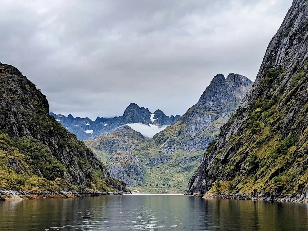
Entrance to Trollfjord

Trollfjord

Sculpture along the coast from Eggum, Lofoten Islands
Continuing our Lofoten Islands exploration, we made our way out to the village of Eggum to hike a coastal route recommended by Lonely Planet. We came upon this beatiful sculpture on the hike. In the background are ruins of an old fort. History and art on one walk.

Free Norwegian roadside potable water fill - with a view
Re-supplying has been easy in Norway. Water is readily accessible and free at roadside pitstops. We have been able to find places to re-fill propane in most cities. Groceries are plentiful - although Norway has been the most expensive country to buy food to date.

Hauklandstranda, Lofoten Islands
Some of the beautiful Lofoten Island beaches that had been open to camping in the past are now campgrounds with a fee. We opted to camp down the coast in our own spot. Rocky but free - and with a rainbow!

View from wild camping spot, Lofoten Islands

A cold night and awakening to the first dusting of snow. Summer’s lease hath all too short a date.

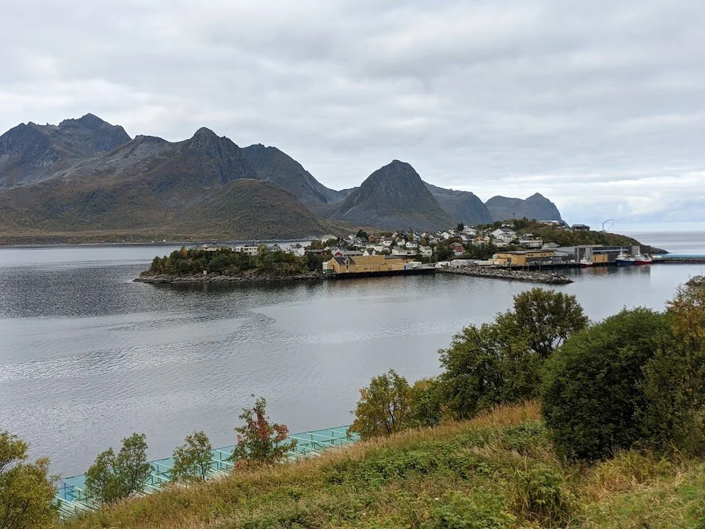
Henningsvaer, Lofoten Islands
We loved the Lofoten Islands but as it was getting colder and we were losing the beautiful light, we made our way back to the mainland and up the coast towards the Northern tip.

Stopped for a walk and were treated to this warning sign along the hike. We were not treated with a troll sighting.
We made one more scenic loop before heading north, driving out to and around Senja island.
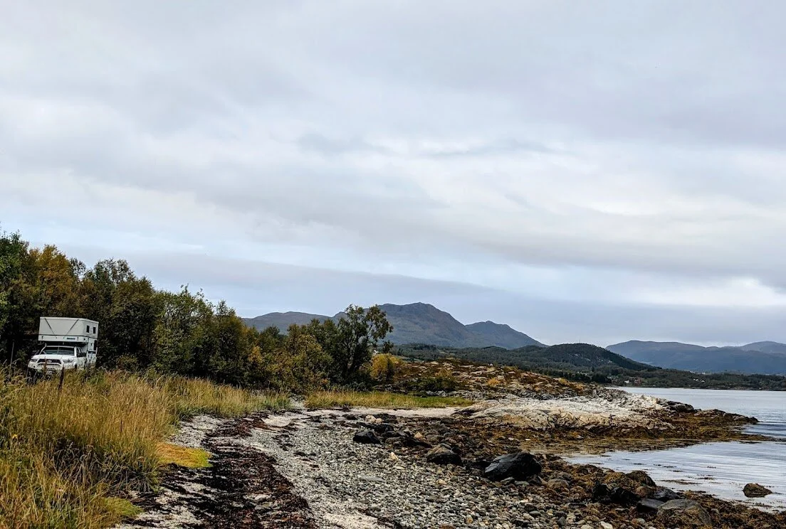
Wild camping along the coast of Senja

Senja coastal route

Loving the daily drive. Lunch packed, walk completed, now just need a place to sleep.
Husøy, Senja, island fishing village

Walk around Husøy and a beautiful park at the tip

Private wild spot with a view of the Lyngen Alps
After leaving Senja, we continued up the northern coast to Nordkapp with the goal of hiking the 12 km trail to the very northern tip. Along the way we stopped in Alta to see the World Heritage rock art center - incredible site with carvings 2,000-7,000 years old along the coast.

Alta Museum - rock art in its original state outside

Alta Museum - rock art re-painted to view details

Stabbursdalen National Park - waterfall hike
In the end, we pivoted our plans. The day of our planned hike to the northern tip (71 degrees north, 2,500 miles from the North Pole) we awoke to 25mph winds, and we were tired, (maybe a little grumpy? it happens) and decided not to attempt it. Instead we made our last Norwegian national park visit and hiked a more sheltered route to this impressive waterfall.
So long Norway, its been a beautiful trip. Onwards to Finland!